                     
As-Built As-Built - Revit As-Built - AutoCAD VirtuSurv - VirtuSurv 2018 As-Built - Modeler VirtuSurv - VirtuSurv 2019          
BuildIT BuildIT - Projector BuildIT - Construction BuildIT - Metrology              
CAM2 CAM2 - SmartInspect CAM2 - 2023 CAM2 - 2018 CAM2 - Measure 10 CAM2 - Measure Q CAM2 - Measure X CAM2 - Measure 3/4 CAM2 - AnthroCAM CAM2 - 2019 CAM2 - 2020
CAM2 CAM2 - 2021                  
Cobalt 3D Imager 3D Imager - Cobalt                  
Cobalt Design Cobalt Design - M Cobalt Design - S Cobalt Design - Dual              
Computers Computers - All Computers                  
FARO Aras 360 & CAD Zone FARO CAD Zone - Fire & Insurance FARO CAD Zone - Crime & Crash FARO CAD Zone - CZ Point Cloud FARO CAD Zone - First Look Pro FARO 360 - Reality FARO 360 - HD FARO 360 - Blitz FARO 360 - Genius    
FARO Connect FARO Connect - Connect                  
FARO Zone present4D - present4D                  
FARO Zone 2D FARO Zone 2D - 2018 FARO Zone 2D - 2019 FARO Zone 2D - 2020 FARO Zone 2D - 2021 FARO Zone 2D - 2022 FARO Zone 2D - 2023        
FARO Zone 3D FARO Zone 3D - 2018 FARO Zone 3D - 2019 FARO Zone 3D - 2020 FARO Zone 3D - 2021 FARO Zone 3D - 2022 FARO Zone 3D - 2023 FARO Zone 3D - 2024      
FARO Zone 3D Advanced FARO Zone 3D Advanced - 2018 FARO Zone 3D Advanced - 2019 FARO Zone 3D Advanced - 2020 FARO Zone 3D Advanced - 2021 FARO Zone 3D Advanced - 2022          
FaroArm/ScanArm FaroArm/ScanArm - Quantum S FaroArm/ScanArm - Quantum M FaroArm/ScanArm - Quantum E FaroArm/ScanArm - Edge FaroArm/ScanArm - Fusion FaroArm/ScanArm - Prime FaroArm/ScanArm - Platinum FaroArm/ScanArm - Legacy Quantum FaroArm/ScanArm - Titanium FaroArm/ScanArm - Advantage
FaroArm/ScanArm FaroArm/ScanArm - Digital Template FaroArm/ScanArm - Gage FaroArm/ScanArm - Quantum S Max FaroArm/ScanArm - Quantum M Max FaroArm/ScanArm - Quantum E Max FaroArm/ScanArm - Gage Max        
GeoSLAM Software GeoSLAM Software - Connect GeoSLAM Software - Draw GeoSLAM Software - Hub GeoSLAM Software - Volumes            
GeoSLAM ZEB GeoSLAM ZEB - Horizon GeoSLAM ZEB - Horizon RT GeoSLAM ZEB - Revo GeoSLAM ZEB - Revo RT GeoSLAM ZEB - Go          
Hand Held Scanner 2D Hand Held Scanner - ScanPlan 3D Hand Held Scanner - Freestyle3D 3D Hand Held Scanner - Freestyle3D X 3D Hand Held Scanner - Freestyle3D Objects 3D Hand Held Scanner - Freestyle 2          
Language Quality HT MT AT NT INT - Internal Sales - Internal Resources Sales - Order and Quote Sales - Product Info Sales - Sales Readiness Sales - Training
Language Quality Sales - Product Launch Sales - Promotions CS - Quote to Invoice CS - Phone System CS - New Hire Training CS - General CS - Product Info CS - Licensing CS - Procedures General CS - Procedures Salesforce
Language Quality CS - Procedures Loaner CS - Procedures SAP                
Languages Language - English Language - Japanese Language - German Language - Chinese Language - Spanish Language - Italian Language - Portuguese Language - French Language - Korean  
Laser Projector RayTracer - RayTracer Laser Projector - Tracer M Laser Projector - Tracer SI              
Laser Radar Imaging Laser Radar - VectorRI                  
Laser Scanner 3D Laser Scanner - Focus S 3D Laser Scanner - Focus M 3D Laser Scanner - Focus3D 3D Laser Scanner - Focus3D X 3D Laser Scanner - Focus3D X HDR 3D Laser Scanner - Focus3D S 3D Laser Scanner - Photon 3D Laser Scanner - Focus S Plus 3D Laser Scanner - Swift 3D Laser Scanner - Focus Premium
Laser Scanner 3D Laser Scanner - Focus Core                  
Laser Tracker Laser Tracker - Vantage Laser Tracker - ION Laser Tracker - Vantage S Laser Tracker - Si Laser Tracker - X Laser Tracker - Xi Laser Tracker - Vantage E Laser Tracker - Vantage S6 Laser Tracker - Vantage E6  
Legacy Gage Legacy Gage - Bluetooth Legacy Gage - Plus Legacy Gage - Standard Legacy Gage - Power            
Legacy Software Legacy Software - CAM2 Gage Legacy Software - Gage Software Legacy Software - Insight              
Mobile Scanner Mobile Scanner - Orbis                  
PointSense PointSense - Basic PointSense - Pro PointSense - Building PointSense - Plant PointSense - Heritage PointSense - Revit CAD Plugin - TachyCAD Building CAD Plugin - TachyCAD Archeology CAD Plugin - TachyCAD Interior CAD Plugin - PhoToPlan Basic
PointSense CAD Plugin - PhoToPlan CAD Plugin - PhoToPlan Pro CAD Plugin - PhoToPlan Ultimate CAD Plugin - DisToPlan CAD Plugin - MonuMap CAD Plugin - hylasFM CAD Plugin - VirtuSurv      
RevEng RevEng - RevEng                  
ScanArm ScanArm - Design ScanArm 2.0 ScanArm - Design ScanArm ScanArm - Forensic ScanArm ScanArm - Design ScanArm 2.5C            
SCENE SCENE - Capture and Process SCENE - WebShare Server and 2Go SCENE - WebShare 2Go App SCENE - 2018 SCENE - 7.x SCENE - 6.x SCENE - 5.x SCENE - 4.x SCENE - LT SCENE - 2019
SCENE SCENE - 2go App SCENE - 2020 SCENE - 2021 SCENE - 2022 SCENE - 2023          
Serial FaroArm Serial FaroArm - Silver Serial FaroArm - Gold Serial FaroArm - Bronze              
Sphere FARO Sphere - Sphere                  
Visual Inspect Visual Inspect - App Visual Inspect - CAD Translator                
WebShare WebShare - Enterprise WebShare - WebShare Cloud                

SCENE

2023

2022

2021

2020

2019

2018

7.x

6.x

FARO® Knowledge Base

SCENE Registration Report App Information

scene-bty.png

Overview

Download and install the SCENE Registration Report app for a simple way to export SCENE registration reports. Save the report as a TXT, CSV, or XML file for processing or viewing. 

Generating a Report

After installing the app, you can generate a report from within SCENE.

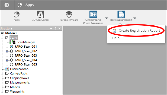
  1. Open the App ribbon.
  2. Click the Registration Report App icon.
  3. Click Create Registration Report.
    RegReport.png
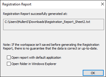
  4. Select a Name for the report, the destination folder, and the type of file to create.
  5. Optional: Check the box indicating program to use with the new file.
  6. Click OK.
    RegReport2.png

General Information

The top of the report will contain general information about the project or scan cluster.

  • Scan Quantity - The total number of participating scans
  • Participating Scans - Scan names.
  • Total _Correspondences - The total number of found correspondences

Individual Scan Information

The general information section is followed by specific information for each scan included in the registration report. These sections contain the following information if present.

  • Scan Name - The name of the scan
  • Inclinometer Usage – Indicates whether inclinometer readings have been used to level the scan during registration or not.
  • Position [m] – The calculated position of the scan in global coordinates.
  • Orientation Axis – The calculated rotation axis of the scan in global coordinates.
  • Angle [°] – The calculated angle of rotation of the scan.
  • Point Distance - The standard deviation of the distance between the local reference points and their corresponding references.
  • Number of Correspondences – Total number of correspondences found between the references of the evaluated scan and the references in other scans.
  • Correspondences – List of all reference pairs used for scan placement. The value Tension describes the discrepancy in the global coordinate system between the position and the orientation of the two corresponding reference objects in Scan 1 and Scan 2. For corresponding reference points, the distance between their positions serves as input for the calculation of the tension. For planes, slabs or pipes, the position and the direction serve as input for the calculation of this value. Values close to zero indicate a good registration result.
  • Matched Objects – List of reference objects that correspond to the references in the currently evaluated scan.
    • Target – The name of the corresponding reference object and its path in the workspace structure:
      • In case there is a corresponding reference object in only one other scan, the displayed path is equivalent to the path of the corresponding object in this scan.
      • In case there are corresponding references in more than one scan, the displayed object is treated as a “mean reference” (mean reference from several scans) and the displayed path of this “mean reference” is equivalent to the corresponding object of the currently evaluated scan.
    • Distance [mm] – The distance between the reference of the currently evaluated scan and its corresponding reference.
    • Longitudinal [mm] – The longitudinal distance between the reference of the currently evaluated scan and its corresponding reference.
    • Angular [°] – The angular distance between the reference of the currently evaluated scan and its corresponding reference.
    • Orthogonal [mm] – The orthogonal distance between the reference of the currently evaluated scan and its corresponding reference.

Additional Information in the XML File

<Units> – This node exists below each <Scan> and <Matched_Objects> node. It specifies the unit for all distances and angles in the report.

See Also

Keywords:

App contains, registration report, content