Pre-Incident Planning with FARO Technology

Overview
There are two main applications where a fire department should be putting FARO® technology to work:
- Pre-incident planning
- Fire investigation
- Fire Investigation is further described in this article: Fire Investigation with FARO Technology
In this article, let’s look at pre-incident planning and see how the FARO solution is ideal for fire departments that perform pre-incident planning.
Pre-incident planning is the process of gathering and recording information that could be critical for making life-saving decisions at an incident. When this process was performed by a fire department, it was originally called “pre-fire planning.” Today, the process is typically called pre-incident planning, or simply pre-planning, and it has broadened to also include planning on how to respond to other incidents such as hazardous material spills, mass-casualty incidents, and terrorist activity.
Why Should a Fire Department Pre-Plan?
Pre-incident planning is proven to save firefighter lives and reduce property damage. A previous chairman of the International Association of Fire Chiefs (IAFC) was quoted as saying: “Probably the biggest things that we’re doing in the fire service to reduce firefighter deaths is fire prevention and prefire planning.”
Four reasons why fire departments want to get serious about pre-incident planning:
- Firefighters can be informed sooner about what conditions may exist within a building they are about to enter
- The Incident Commander will know more about the building construction and any hazardous materials so they can make informed decisions about actions to recommend
- Once inside the building, fire fighters can be given better directions about where to go, especially when visibility is reduced by smoke
- In the United States, having effective pre-planning can improve a fire department’s Insurance Services Office (ISO) rating, which results in lower homeowner’s insurance premiums in the community. Smart ways to improve your ISO rating | Applied Information (appinfoinc.com)
FARO Zone 2D Delivers Accurate and Consistent Diagrams
In years past, pre-incident diagrams and the associated information were usually copied on paper and stored in three-ring binders in the department’s vehicles. Someone would have to search through the binders to find the pre-plan for the location of the incident. Fortunately, technology today provides a much better solution.
Innovative fire service agencies are using FARO Zone 2D software to create better quality pre-incident plan diagrams that are more easily updated than the old, manual plans. When a building is inspected in the future, that electronic diagram can be quickly changed to show all modifications and additions.
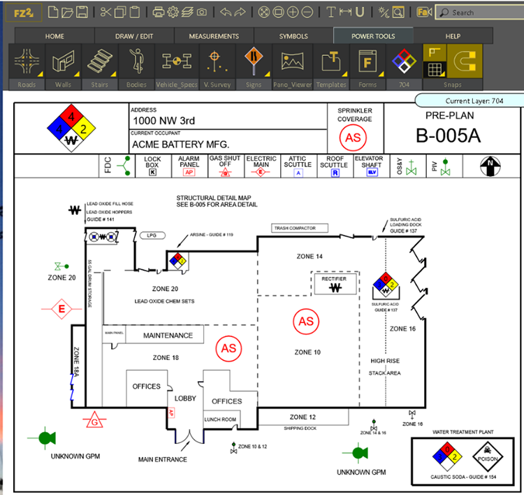
Pre-incident plan diagram created in FARO Zone 2D. FARO Zone has a special feature to fill in the NFPA 704 placard used to document the location of hazardous materials in the United States.
FARO Zone is not just a generic drawing program. It has features specifically for creating pre-plans, such as adding a completed 704 placard. It also includes hundreds of pre-drawn NFPA and other industry-standard symbols commonly used to show hydrant locations, elevators, stairs, sprinklers, FDCs, alarm panels, and utility shut-offs. These features reduce the time it takes for firefighters to learn to use the software and ensure the resulting preplans are accurate and consistent.
Aerial photographs from Google or Bing Maps can also be added to a FARO Zone preplan diagram to show surrounding streets or even an entire block of buildings. This instantly gives the Incident Commander important site information such as where alleys are located, where street access is especially narrow, and potential places to stage. If a full floor plan is not available, the footprint of a building can be traced and measured from the aerial map to create a basic site diagram in just a few minutes.
City or county planning departments typically have electronic drawings of newer commercial buildings, and these are an important resource for creating pre-incident plan diagrams. FARO Zone 2D can import diagrams in the standard computer-aided design formats of .dwg and .dxf. Special tools make it easy to delete unneeded information and add the details required to turn the floorplan into a pre-incident diagram.
Today, most fire departments have mobile computers in their apparatus, so FARO Zone pre-incident diagrams, along with other critical building information, can be stored on those computer hard drives or on the agency’s network server. FARO Zone can export diagrams to common formats so they can be easily attached to whatever records management or dispatch software system the agency uses.
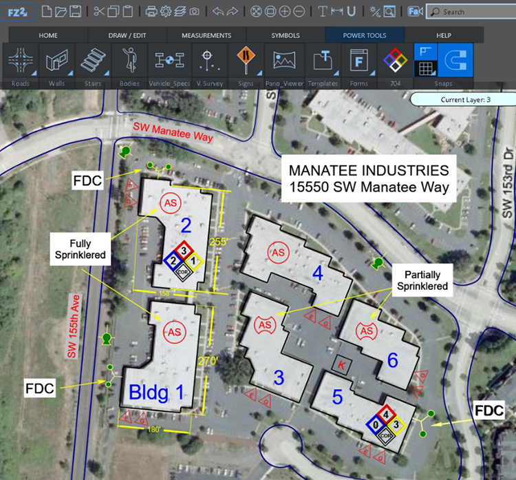
Bring a satellite map from Bing or Google into FARO Zone 2D to quickly create a site plan that shows streets, nearest hydrants, utility shut-offs, ect.
Trust FARO with Your Pre-incident Plans
The FARO Zone development team has been providing pre-planning software to fire departments for more than 25 years. Thousands of fire departments trusted The CAD Zone’s Fire Zone software for pre-planning. FARO Zone is the next evolution of that software and was created by the same developers.
Having accurate, detailed, pre-incident plans is proven to help improve firefighter safety and reduce property damage. Fire departments who want the best preplanning tools choose FARO Zone software to complete their pre-incident plan diagrams.
Click the “Try it for Free” button on FARO.com to download and install a free trial of FARO Zone 2D. Before you buy, create an account on FARO Academy and sign up for a free, online training course. See just how easy it is to have perfect pre-incident plan diagrams with FARO Zone.