                     
As-Built As-Built - Revit As-Built - AutoCAD VirtuSurv - VirtuSurv 2018 As-Built - Modeler VirtuSurv - VirtuSurv 2019          
BuildIT BuildIT - Projector BuildIT - Construction BuildIT - Metrology              
CAM2 CAM2 - SmartInspect CAM2 - 2024 CAM2 - 2023 CAM2 - 2018 CAM2 - Measure 10 CAM2 - Measure Q CAM2 - Measure X CAM2 - Measure 3/4 CAM2 - AnthroCAM CAM2 - 2019
CAM2 CAM2 - 2020 CAM2 - 2021                
Cobalt 3D Imager 3D Imager - Cobalt                  
Cobalt Design Cobalt Design - M Cobalt Design - S Cobalt Design - Dual              
Computers Computers - All Computers                  
FARO Aras 360 & CAD Zone FARO CAD Zone - Fire & Insurance FARO CAD Zone - Crime & Crash FARO CAD Zone - CZ Point Cloud FARO CAD Zone - First Look Pro FARO 360 - Reality FARO 360 - HD FARO 360 - Blitz FARO 360 - Genius    
FARO Connect FARO Connect - Connect                  
FARO Zone present4D - present4D                  
FARO Zone 2D FARO Zone 2D - 2018 FARO Zone 2D - 2019 FARO Zone 2D - 2020 FARO Zone 2D - 2021 FARO Zone 2D - 2022 FARO Zone 2D - 2023 FARO Zone 2D - 2024      
FARO Zone 3D FARO Zone 3D - 2018 FARO Zone 3D - 2019 FARO Zone 3D - 2020 FARO Zone 3D - 2021 FARO Zone 3D - 2022 FARO Zone 3D - 2023 FARO Zone 3D - 2024      
FARO Zone 3D Advanced FARO Zone 3D Advanced - 2018 FARO Zone 3D Advanced - 2019 FARO Zone 3D Advanced - 2020 FARO Zone 3D Advanced - 2021 FARO Zone 3D Advanced - 2022          
FaroArm/ScanArm FaroArm/ScanArm - Quantum S FaroArm/ScanArm - Quantum M FaroArm/ScanArm - Quantum E FaroArm/ScanArm - Edge FaroArm/ScanArm - Fusion FaroArm/ScanArm - Prime FaroArm/ScanArm - Platinum FaroArm/ScanArm - Legacy Quantum FaroArm/ScanArm - Titanium FaroArm/ScanArm - Advantage
FaroArm/ScanArm FaroArm/ScanArm - Digital Template FaroArm/ScanArm - Gage FaroArm/ScanArm - Quantum S Max FaroArm/ScanArm - Quantum M Max FaroArm/ScanArm - Quantum E Max FaroArm/ScanArm - Gage Max        
GeoSLAM Software GeoSLAM Software - Connect GeoSLAM Software - Draw GeoSLAM Software - Hub GeoSLAM Software - Volumes            
GeoSLAM ZEB GeoSLAM ZEB - Horizon GeoSLAM ZEB - Horizon RT GeoSLAM ZEB - Revo GeoSLAM ZEB - Revo RT GeoSLAM ZEB - Go          
Hand Held Scanner 2D Hand Held Scanner - ScanPlan 3D Hand Held Scanner - Freestyle3D 3D Hand Held Scanner - Freestyle3D X 3D Hand Held Scanner - Freestyle3D Objects 3D Hand Held Scanner - Freestyle 2          
Language Quality HT MT AT NT INT - Internal Sales - Internal Resources Sales - Order and Quote Sales - Product Info Sales - Sales Readiness Sales - Training
Language Quality Sales - Product Launch Sales - Promotions CS - Quote to Invoice CS - Phone System CS - New Hire Training CS - General CS - Product Info CS - Licensing CS - Onboarding CS - Procedures General
Language Quality CS - Procedures Salesforce CS - Procedures Loaner CS - Procedures SAP              
Languages Language - English Language - Japanese Language - German Language - Chinese Language - Spanish Language - Italian Language - Portuguese Language - French Language - Korean  
Laser Projector RayTracer - RayTracer Laser Projector - Tracer M Laser Projector - Tracer SI              
Laser Radar Imaging Laser Radar - VectorRI                  
Laser Scanner 3D Laser Scanner - Focus S 3D Laser Scanner - Focus M 3D Laser Scanner - Focus3D 3D Laser Scanner - Focus3D X 3D Laser Scanner - Focus3D X HDR 3D Laser Scanner - Focus3D S 3D Laser Scanner - Photon 3D Laser Scanner - Focus S Plus 3D Laser Scanner - Swift 3D Laser Scanner - Focus Premium
Laser Scanner 3D Laser Scanner - Focus Core 3D Laser Scanner - Focus Premium Max                
Laser Tracker Laser Tracker - Vantage Laser Tracker - ION Laser Tracker - Vantage S Laser Tracker - Si Laser Tracker - X Laser Tracker - Xi Laser Tracker - Vantage E Laser Tracker - Vantage S6 Laser Tracker - Vantage E6  
Legacy Gage Legacy Gage - Bluetooth Legacy Gage - Plus Legacy Gage - Standard Legacy Gage - Power            
Legacy Software Legacy Software - CAM2 Gage Legacy Software - Gage Software Legacy Software - Insight              
Mobile Scanner Mobile Scanner - Orbis                  
PointSense PointSense - Basic PointSense - Pro PointSense - Building PointSense - Plant PointSense - Heritage PointSense - Revit CAD Plugin - TachyCAD Building CAD Plugin - TachyCAD Archeology CAD Plugin - TachyCAD Interior CAD Plugin - PhoToPlan Basic
PointSense CAD Plugin - PhoToPlan CAD Plugin - PhoToPlan Pro CAD Plugin - PhoToPlan Ultimate CAD Plugin - DisToPlan CAD Plugin - MonuMap CAD Plugin - hylasFM CAD Plugin - VirtuSurv      
RevEng RevEng - RevEng                  
ScanArm ScanArm - Design ScanArm 2.0 ScanArm - Design ScanArm ScanArm - Forensic ScanArm ScanArm - Design ScanArm 2.5C            
SCENE SCENE - Capture and Process SCENE - WebShare Server and 2Go SCENE - WebShare 2Go App SCENE - 2018 SCENE - 7.x SCENE - 6.x SCENE - 5.x SCENE - 4.x SCENE - LT SCENE - 2019
SCENE SCENE - 2go App SCENE - 2020 SCENE - 2021 SCENE - 2022 SCENE - 2023          
Serial FaroArm Serial FaroArm - Silver Serial FaroArm - Gold Serial FaroArm - Bronze              
Sphere FARO Sphere - Sphere                  
Visual Inspect Visual Inspect - App Visual Inspect - CAD Translator                
WebShare WebShare - Enterprise WebShare - WebShare Cloud                
FARO® Knowledge Base

Export Scan Settings in SCENE

scene-bty.png

Overview

When exporting scans, SCENE export settings allow you optimize file creation to fit quality and size needs.

Exporting Scans

Exporting Project Scans or Point Clouds

  1. To export all of the scans in a project, click Export Scans on the Export ribbon.
    SCENE Export2.png
  2. Click Export Scan Point Clouds - Unordered or Export Scans - Ordered. (Click here for an explanation of the two choices.)

Exporting Individual Scans or Clusters

  1. To export specific scans or clusters, right-click the desired items in Structure view.
  2. Click Export in the menu.
    SCENE Export New.png
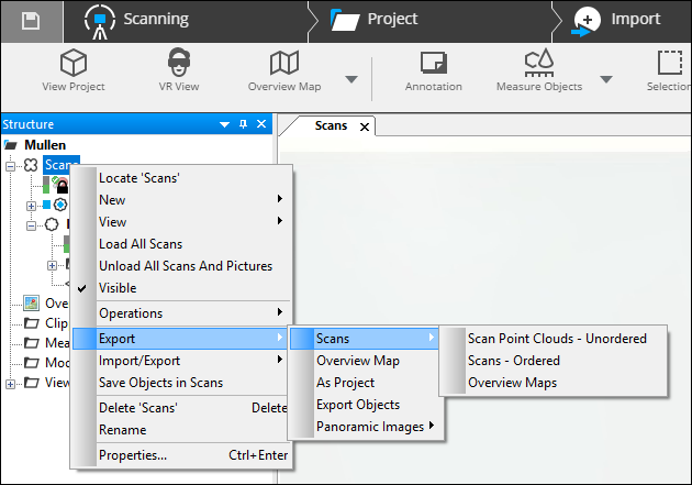
  3. Click the type of file to export and either the ordered or unordered format.

Export Settings

After selecting a file type and save path, you can modify export settings to adjust to your needs.

SCeNE Export3.png

Full Scan / Selection - Full Scan and Selection become available only when exporting from a single scan within the tree or from a point selection.

Min. DistanceMax. Distance - These values determine the minimum and maximum distance a scan point must be from the scanner to be exported. Points closer than the minimum or beyond the maximum values will not be exported. Decreasing the number of points exported will decrease file size.

Subsample - Increasing the Rows or Columns settings, determines how many rows or columns of points are exported. A value of 1, exports every row or column. A value of 2, exports every other row or column. A value of 10 exports every tenth row or column, and so on. 

Color and Grey - When checked, this option exports RGB and grayscale (intensity) values of each scan point, if available.

Slice Settings

Some file formats, allow you to export a slice of the scan within the specified top and bottom limit. Supported file types include: CPE, DXF, IGES, PTS, Pointtools POD, VRML, and XYZ.

SCENE Export4.png

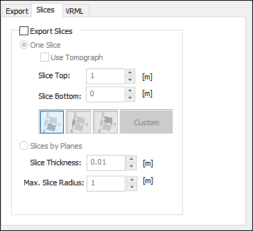
Export Slices - Check this box to export a slice of the scan.

One Slice - Exports a single scan slice.

To export a slice, you will need to define the orientation of the section by clicking one of the pre-selected options or selecting a custom scan.

SCENE Export5.png

  • Slice Top - Defines the top of the slice by distance from the plane.
  • Slice Bottom - Defines the bottom of the slice by distance from the plane.

For example - An XY slice with a top of 2 and bottom of 1 would create a slice parallel to the bottom of the scan beginning 1m above the plane and ending 2m above the plane.

Slices by Planes - Exports multiple slices.

  • Slice Thickness - Determines the thickness of each plane exported as a slice.
  • Max. Slice Radius - Determines the width each slice exported.

Specific File Settings

VRML

SCENE Export6.png

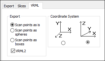
VRML settings allow you to export scans as spheres and boxes for use in programs that do not support points. You can also change the coordinate system and export to a VRML 2 format.

DXF

Check the Export Object Names box if the names of selected objects should be exported.

XYZ

Include row/col - Include row and column information in the exported file.

Export raw reflections - Include raw reflection values in the exported file.

IGES

SCENE Export7.png

Enter Part, Author, or Organization information in the corresponding fields.

Represent Scan Points - Click Points or Spheres to specify how scan points are displayed.

Set Color to:

  • IGES default - The export file does not contain any level specifications so the CAD system will use the default level.
  • Scan point color - Use the gray value or color value of the scan point.
  • Scan specific - If the export consists of several scans, the scan points from the different scans will have different colors. 

Set Level to:

  • IGES default - The export file does not contain any level specifications so the CAD system will use the default level.
  • Scan specific - If the export consists of several scans, the scan points from the different scans will have different levels.

Objects

  • Unbounded Planes - The idealized planes without border are also exported as idealized and without border. Otherwise a square is exported.
  • Export Object Names - Object names are exported.
  • Level - Level allocation for object names.

Pointools POD

SCENE Export8.png

Compression Accuracy - POD files compress cloud data. You can set the level of accuracy you want to maintain. It is important to consider the accuracy of the instrument used to acquire the data and to not set the compression accuracy too high. 

Normal Generation - Normals are required for point lighting. This data is either imported from the source file or generated upon import.

  • Normal – No altering.
  • Sharpest, Sharper, Sharp - Quality of normals, degree of faceting on object’s surface. 
  • Smoothest, Smoother, Smooth - Quality of normals, degree of curvature on object’s surface. 

Spatial Filter Strategy - For advanced users. Default setting is usually sufficient.

Spatial Filter Accuracy - Much like the compression accuracy, setting this too high may result errors.

CPE

SCENE Export9.png


  • Numerical Resolution - Use one of the preset settings depending on the type of scan data or your own desired value.
  • Color - Set the number of colors used for the exported scan points to True Color or High Color for a smaller file size, but with a reduced visual quality of color gradients.
  • Export Raw Reflections - Uses reflection values between 0 and 2047 for the FARO® Laser Scanner. 
  • Export Normals Vectors - Export the normal vectors of the scan points.
  • Estimated size - The estimated file size in MB per million exported scan points.