Overview
In September 2022, FARO launched its new Augmented Reality App Flatness Check - an iPad app that works with your FARO Focus laser scanner to quickly find and document flatness variations in concrete slabs and other floor surfaces. In February 2023 ConstructioNext announced, FARO’s Flatness Check App won two Innovative Product Awards (IPA) at the World of Concrete (WOC) tradeshow hosted in Las Vegas that year.

Here you can quickly find information about any enhancements that were introduced to the app since the launch.
June 2023
- Add your customized views to the report
- With this release Flatness Check users can now add as many views as needed to the html-report. Adding multiple views to the report helps documenting the important areas of your deck with high detail information. The views will contain all visible annotations, can be created from all analysis methods and in both view methods (analysis only / AR-view)
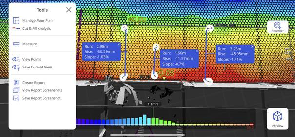
- Document critical slopes – Line measurement
- The App now provides in the result view the option to add 2-point measurement lines. If critical areas are detected by the colorization, now users can add a line annotation to the view. This will display the run length, the rise and the slope along the line.
- View Cut & Fill Region Statistics
- While the analysis provides information on each cut or fill region as well as a summary, sometimes customers want to understand cut or fill information just for a few regions. With this release, users can now simply select as many regions as desired and see the summary in the view. Each selected area will turn green and the summary shows the values just for these regions.

- Flatness Check looks even nicer now
- Beside the features mentioned above, we were also working on several smaller user interface updates to make the daily work with the app even more convenient for our users.
- Complete Trial Workflow without Focus Scanner
- Now trial users can complete the full Flatness Check workflow even without a FARO Focus Scanner. Leveraging the iPad LiDAR capability, it is possible to scan a floor for testing purposes and see the app value within minutes. Give it a try and if you want to add precision to the speed, reach out to us and setup some time for a FARO Focus demonstration.

- Consistent Reference Benchmark through RAD Marker Detection
- Precision and Repeatability are crucial pieces for delivering high quality concrete slabs. Flatness Check now provides a very simple method to analyze several scans against the same benchmark. By placing a RAD Marker to the reference height marker, users can consistently evaluate quality against the same benchmark on the whole slab faster and take actions to fix issues immediately. More details on this can be found here: Using RAD Reference Height Markers in FARO Flatness Check.
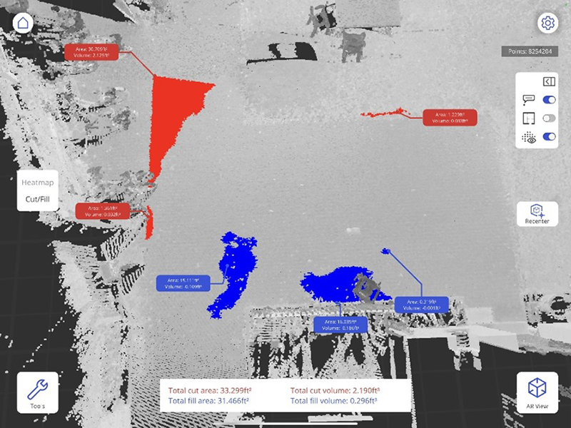
- Cut & Fill Analysis
- Precisely knowing the volume and area for a region to fix is crucial for precise time and cost estimation. Therefor we added a new analysis method to the app that helps documenting exactly this information. Once the heatmap analysis is completed, users get a good understanding of high and low spot area locations. Now it’s possible to do a 2nd analysis, focusing on the areas to fix.
The analysis will not only display the areas for cut and fill in AR. It also provides for each area the volume and surface. On top it also provides total information for both, so that an estimation for the whole deck can be completed within minutes. Leveraging the AR view enables concrete contractors and floor finishers to clearly spot the work areas and focus their effort on the areas that matter.
- Save AR-Views
- Identified issues can now be documented easily in the App using the Save Current View command under the Tools tab. This enables a quick understanding of issues in the real-world context even when being off site.

- Improved Floor Extraction within Selection
- The app is leveraging now new technologies and enhanced processes to better identify the areas that are relevant for the analysis. With this, the analysis now considers also areas divided by obstacles as one analysis area.
- User can now better identify the priority of a deviation and plan their actions more precise by using a floor plan overlay. With just a few clicks, they can bring a pdf, jpg or png to the current analysis and overlay. This helps realizing deviations under glass walls (for example) easier, which have higher floor flatness requirements
- Users can now also share identified floor levelness issues externally by creating an html-document and using common Apple Share mechanisms to bring the documented results to their stakeholders
- The user interface in the analysis view has been enhanced, so users can now toggle on/off the visualization of the context point cloud. This helps Flatness Check users to better understand the analysis results by seeing the complete scan area and identify locations of issues.
- Support E57-format
- Now you can bring in point cloud data by using the vendor-neutral *.e57 file format. Visualize through Flatness Check’s augmented reality view the analysis results, based on scans from any terrestrial laser scanner device
- Scan Registration Details
- Get more insights on the scan registration quality. Whenever a new scan is added to the captured data in a project, the app will now display some details on the registration accuracy to help you decide faster if registration quality was sufficient
- Annotations displayed in fractional numbers
- Quickly specify in the options dialog the preferred method for displaying annotation values in imperial units

- Extended Scan number capability
- Continuous performance enhancements in the app enable users now running more than 3 scans within one on-site analysis. Therefor a larger concrete slab area can be analyzed quicker. Depending on the iPad, we recommend up to 10 scans per analysis. More information on the recommended iPads can be found here.
- Add more annotations manually
- Place an annotation wherever you need more clarity on an issue. Annotations are also shared through Sphere Synchronization for data consistency
- Import BuildIT Construction Analysis
- Enable on site visualization of complete deck analysis results by bringing a complete Analysis created in BuildIT Construction 2022.5 (or higher) into FARO Flatness Check and identify critical issues on the complete concrete deck


- Annotations for Highest and Lowest Point
- Clearly understand deviation sizes from automatic annotations, placed on the highest and lowest point in the analysis area
- Viewing License
- Benefit from a free Viewing License to visualize shared analysis results on your iPad
- Beta-Feature: Auto-Alignment
- Quickly scan the surroundings of your slab with the iPad to automatically align the analysis result with the augmented reality. Note: This feature is currently in Beta-Status and will be further enhanced in the future
- Scan file names on Scanner SD-card according to project name
- For an easier identification and scan data consistency, the project name is included for any scan, started from the app. This enables an easy data coordination within all FARO software products (e.g.: Scene, BuildIT Construction)
- Optimized Project Data Synchronization with FARO Sphere
- Benefit from shorter data synchronization between FARO Sphere and Flatness Check with less data traffic
- Add Scans to existing projects
- Increase the Analysis Area by adding one or more scans to an existing project, directly from your iPad
- Keep Analysis Parameters
- Prevent redundant efforts for completing analysis parameters when it was defined already in previous analysis
- Fractional Input for size parameters
- Speed up the configuration process by enabling data input with fractional numbers for imperial units